|
|
|
|
|
|
|
|
|
|
 |
|
| More Photos of Petra |
Inside the Treasury
|
Wadi Rum
|
|
|
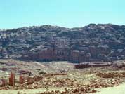
Petra is one of the most incredible sites in the world and well worth the major effort it takes to get there. Located at the crossroads of the flourishing overland caravan trade routes, the city of Petra prospered as the capital of the Nabataean empire from 400 B.C. to A.D. 106. The Nabataeans engineered an impressive system of pipes, tunnels, and channels that carried drinking water into the city and reduced the chance of flash floods. This water system is still evident today along the walls of the city. |
|
|
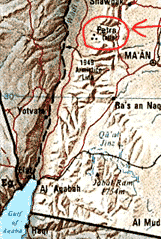
Petra is Located near the western border of Jordan. It is a 4-hour drive from Amman.
|
|
|
|
|
|
| The Romans annexed Petra in A.D. 106, and its position as a commercial hub slowly deteriorated. The Byzantines made the city the seat of a bishopric in A.D. 379 before earthquakes and an economic lull took their toll. By the end of the Byzantine Empire (circa A.D. 700), the hydraulic system and the once dignified and gracious buildings in the center of town had deteriorated to near ruins. |
|
|
Click on this for a larger image. It clearly shows the difference between the architectual periods.
|
|
|
|
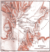
Here is a map of Petra drawn in 1812. Click on the map for a larger view.
|
 |
|
| In the centuries that followed, Petra disappeared from most maps and was known only through ancient lore. In 1812 Swiss traveler Johann Burckhardt snuck into the mythic city disguised as a Muslim trader and then told the world about what he found. |
|
|
|
|
|
|
|
|
|
|
|
|
|
|
|
|
|